August 1. Playa del Palmar, Spain
Well the internet connections is almost non-existent. As such, I am not going to be able to upload any pictures. If I can, I will post an amended version with photos later.
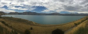
Wow, the heat is incredible! I drank more water today than I did on the entire first stage of this ride–and still, it was not enough. I set the alarm for 6:00 AM, but did not get on the road until after 9:00 AM. That has got to stop or I’ll be doing Spain on 30 mile days.
Today was the first day of the ride using the approved European bike route that I got from the website
The importance of this bit of information is that I am doing MOST of Europe using established routes, from this website. Further, the website allows you to download their routes as a GPX file, which can be imported directly into a number of navigation programs. The practical upshot: you see a map of the area, the red line that shows the route you are supposed to follow, and a blue dot that shows where you are at the moment.
I started out from the campground riding on a really nice road–good shoulders, hardly any traffic, no hills to speak of, basically, the ideal cycle touring scenario. But after I while, I checked my navigation App and realized that I had biked about 200 yards past my turn. Hey, it could have been worse. So, I rode back to take the road that I was supposed to take, according to the above website.
The road led down past a little restaurant/bar and off into some hills. I followed it and after a mile, I ran into a maintenance crew. OK–I’ve done this a hundred times. This is no different–it’s just in Spanish, that’s all. The crew was running a couple of front end loaders and a large backhoe, moving tons of sand from the road. After about 100 yards, it became clear that I was going to have to get off my bike and push it through the sand. Sand is not a cyclist’s friend. After about 10 minutes of this, I was able to get back on the bike and ride.
Now, I was surprised when the road turned to dirt–dirt, by the way, worse than any I had encountered along the Alaskan highway. But, hey! It’s the official bike route, right? Push on!
Well, after a while, I started seeing signs that said something like “Military Zone. Keep out!” This place was a dump, lots of abandoned buildings and such. So, I figured that it probably wasn’t a real military zone. So…. I kept riding.
After about a mile, this road turned into an even smaller road, still dirt. And then, it turned into a cattle path. Even if I were on a mountain bike, with no panniers, I don’t think I could have made it…loose dirt and sand and steep hills. Yikes!
I saw an official-looking vehicle and thought, “Oh no! It’s the military coming to arrest me. I hope those Spanish prisons have air conditioning.” I had since become frustrated with having to keep track of my wallet, all of my cash, and my passport individually, and so put then in a common container–in the back of my bike jersey. I discretely burried it all in the bottom of a pannier, and approached the individual.
“Senior, this is a Sun Trail (Yes! He spoke a little English.) You would have to carry your bike; you cannot ride it.”
What? I was riding on the “Official Bike Route.” It said so on the internet. Are you telling me that the internet might actually be in error? OK, not the first time that has happened. But do you see the implications? I am planning the next 2 months based on that web site!
So, I thanked the man and turned my bike around and rode through all of the stuff a second time. In the end, it only cost me about 90 minutes. But I am going to have to be very careful (whatever that means) as I go forward. Sheesh.
I got back on the main highway, which would also take me to where I needed to be. I saw a lot of really cool things along this road; sure wish I could post some pictures. But, eventually, I ran into an interesting sign. It had a lot of little symbols: a man pulling a cart, a horse, a tractor, and they all had red circles around them. Oh yes–there was also a bike on that list. At this point, the road became an “Autopista” or an official highway, or something. And bikes were not allowed.
I checked the map and saw that I could take a different road down to the coast where I would meet up with the bike route, and all of the campgrounds. I figured that they must have banned bikes from the highway out of safety, right? Wouldn’t want to expose me to any unecessary risk. So, I took the other road, over hills down to the beaches.
I have to say that this was, by far, the most dangerous road I have ridden on in my life (so far). No shoulder, and constant speeding traffic. Many times, the road was lined with guard rails and, if I were to have been hit, I would be smooshed, rather than knocked off the road. I would have been to the campground in 10 seconds flat, so to speak.
Well, I got through that somehow, but it would have been a whole lot easier if I could have just taken the autopista. Less traffic, I am sure. And there were shoulders.
After a bit of looking around, I found the campground where I will be sleeping tonight. I was encouraged by last night, because they only wanted 15 Euros. Well, this campround wanted 25, and they double-sold my spot. I have to share it with another tent!
Even so, I really like this Spanish idea of camping. Everyone crams into a really small space, but there is a resturant, a bar, a store, and all kinds of things for kids to do. No one is uptight, and everyone seems to be happy. We could take an example from these folks…
Although I did an honest day of biking, I lost a lot of miles from backtracking. My goal is to actually be biking tomorrow by 6:30 AM. It really is too hot to be bicking after 2:00 PM. Another day, and another adventure!
 Previous Post
 Next Post
That website sure LOOKS legit. Any way I can help?
It looks like your adventure continues. Keep up the good work and stay cool.
Thanks Jean-Marc! The main thing is that it will be 10C cooler and I can bind dell day if necessary!
I cannot help much for Spain, but you will have the same problem of roads with rails and no shoulders in France.
Bikes are not allowed on “autoroutes” and “voies rapides” (equivalent to autopistas in Spain).
But there are “voies vertes” (greenways) which are dedicated paths for bicycles and also veloroutes where you have green ways and / or low traffic roads.
Problem is that many projects are still unfinished (see map below).
http://af3v.org/CarteAF3V/carte-detaillee.html
Following canals is a very good way to go from the Atlantic ocean to the Mediterranean with no cars or trucks but it may not be completely on your planned itinerary.
The paths along the “canal du midi” are open to bicycles (no cars) and partly paved (full green lines on the map). The unpaved paths are also OK by dry weather (striped green lines on the map).
http://www.canal-et-voie-verte.com/La-carte?zoomifyXMLPath=carte%2Fatlantique.xml&zoomifyHotspotsXMLPath=carte%2FHotspots%2Fhotspots.xml
The map also provides information on lodging, food stores and cycle repair shops.
And don’t hesitate to contact us when you are in France and particularly in the Toulouse area.
Jean-Marc